
A small map
of the area showing the Viaduc des
Egratz (in blue and yellow) - part of the main N205
route from the A40 to Chamonix. Constructed in 1981,
an addition to the old road that hugs the cliff face to
improve traffic flow, especially in Winter. |

Seen from the
village of Chedde, the Viaduc des
Egratz carries the N205 up into the Chamonix valley. |
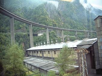
The Viaduc des
Egratz with the old road hugging the
cliff face behind, plus a yucky aluminium factory
in the foreground. A good aerial photo of the road and
factory can be found HERE. |

The road starts
off at ground level and gradually climbs
up to the top of a cliff face and on towards
Chamonix-Mont-Blanc. |

Here at the
tallest point - each of the concrete
pillars are approximately 68 metres in height. |

A magnificent
feat of engineering - the Viaduc des
Egratz snaking its way through the landscape, with
the railway track winding its way beneath!
The road is about 2.2km long. |